The Stuff of Sagas
The boat that had carried us the short hop across the icy
turquoise waters from Narsarsuaq to Qassiarsuk recedes across the fjord,
weaving its way past icebergs, leaving a faint white wake. It’s so quiet, the
sound of its engine humming like an angry hornet takes ages to fade. The mid-August sun is
hot on my shoulders as we make our way up the small jetty of this sleepy sheep
farming community to begin a six day trek across a peninsula called Erik the
Red’s Land to the fishing port of Narsaq, which a prominently placed sign
states is 50 kilometres away. A traverse across the peninsula is marked on the
1:100,000 scale map of the area. However, as we found out during trekking in Klosterdalen, Tasermiut Fjord, this map, like the one we used there, is unlikely to be very accurate, and navigating in poor weather
would be a challenge to say the least. We are well prepared, and are carrying a satellite phone and a DeLorme InReach satellite device that allows 2-way SMS and email messaging.

The signpost also mentions ‘Ruiner’, which refer to some of
the most interesting and important Norse remains in Greenland .
Qassiarsuk is close to the late 10th century farmstead, Brattahlíð, which
is mentioned in the Saga of Erik the Red. Supposedly founded by him, it is the
first Viking settlement in Greenland and the first to be established in America by
Europeans. Several archaeological excavations in the nineteenth and twentieth
centuries uncovered the foundations of late-medieval buildings, including a
church with a rectangular churchyard containing human remains, and a well
preserved long house. But in 1961, during the building of a school hostel
around 200 metres away from the excavated church, several human skulls were
unearthed, and in 1962 five excavations took place which revealed a small
church with a stone floor and thin wooden walls banked by layers of turf
surrounded by a circular churchyard containing 150 interments.

In 2000, to celebrate the millennium of Norse settlement in Greenland , the Icelandic government funded a
reconstruction of a long house and Thojdhild’s church, complete with period
furnishings. For 50 kroner you can visit both of these buildings. There’s also
a prominently placed statue of Erik’s son, Leif, not far from the jetty. Leif was
allegedly the first European to cross the North Atlantic and discover the Americas, a region he named Vinland . It’s therefore not hard to see why the Narsaq
Peninsula has been named Erik the Red’s Land in the Norseman’s honour, and the
‘ruins’ and reconstructions are worth an hour of anyone’s time before setting
off along the unsealed road towards the sheep farming community of Sillisit some
14 km away.


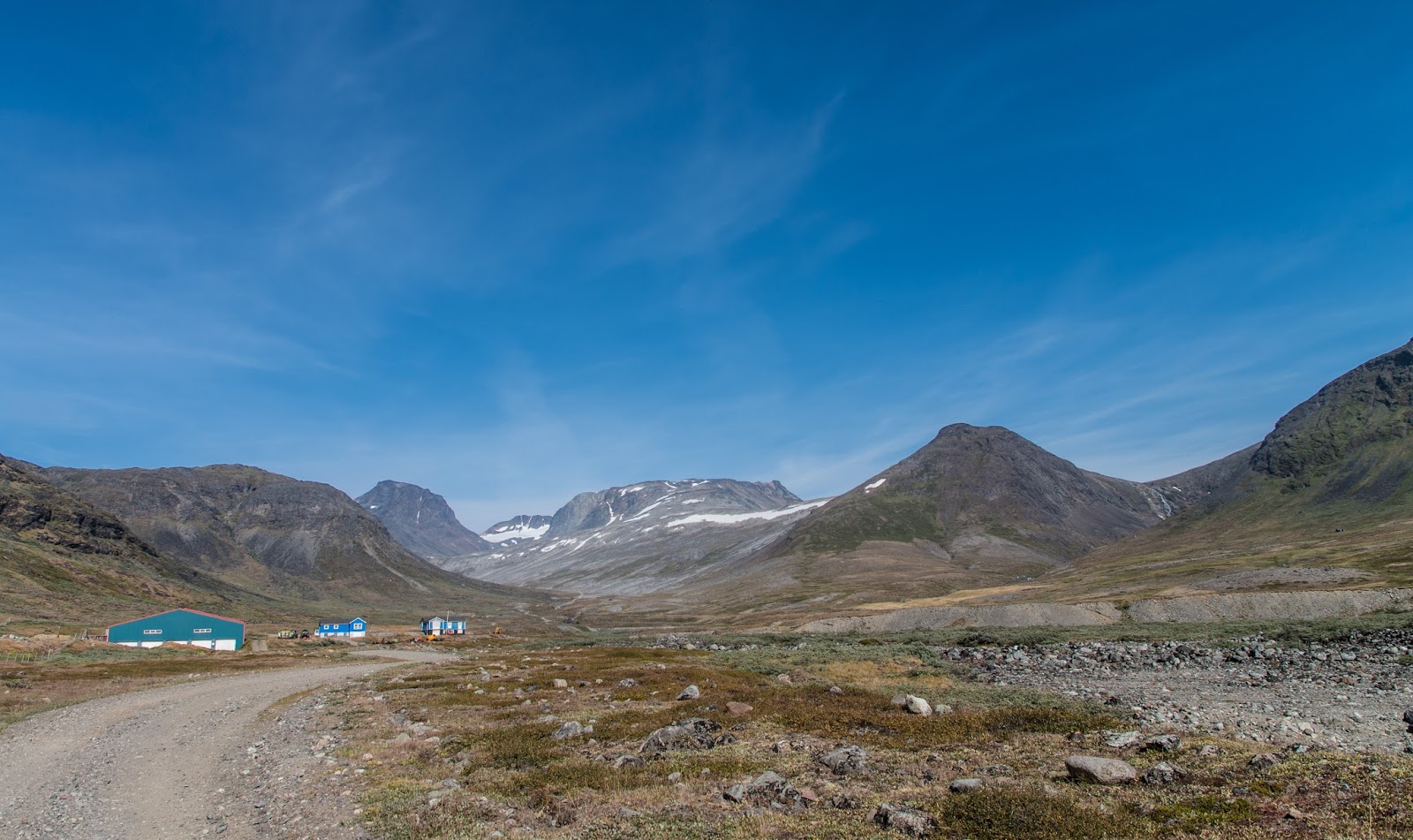
Our feet kick up clouds of rust red dust which coat the surrounding grassland as we climb a rough track that runs through areas of
scrubby grass above Qassiarsuk, its houses hugging the shore in a jumbled mass
of brightly coloured dots. It’s harvest
time and so precious is this grass as animal fodder that it has been mown round
natural obstacles such as large boulders and rocky knolls, and much of it is lying
in felled lines on the ground, or has already been baled in white plastic as silage to
be fed to the flocks of sheep that will be kept indoors during the long Arctic
winter. We are surprised at how parched the landscape is. Local farmers are
bemoaning the weather; while in Ireland
we have seen little of summer beneath leaden skies dampening our spirits with
almost continual mist and rain, here it’s been hot since June with little rain
after a brutally cold winter, and crop yields are down 20 per cent on last
year. Agriculture here is marginal at the best of times and this long spell of dry
weather is little short of a disaster.

The day is warm and muggy with thin cloud trapping the heat
as we pass by a large lake with aquatic plants fringing its boggy shore, its
still deep blue surface the perfect mirror to reflect some snowy peaks that
rise behind it. Tiny blue gentian dot the scrubby grass and the haunting cries
of white-tailed sea eagles, who put on a stunning aerial display, accompany us
as we climb high above the fjord, its turquoise water peppered with icebergs.
The track weaves its way past many lakes and I am pleased to discover that
midges and mosquitoes are far less troublesome here than further south in
Tasermiut Fjord. Indeed, mosquitoes appear to dislike land on which sheep are grazed,
but there is still the odd one around and I have taken every precaution not to
get bitten! A couple of farmers heading to and from the farmsteads near Sillisit pass by us in jeeps with friendly waves, but apart from a couple of dishevelled
French day trippers who are struggling uphill like a pair of wind broken horses
en route to Qassiarsuk, we see no one else.

A long, undulating trackway now takes us down towards the
fjord where masses of jagged icebergs, stranded on submerged glacial moraine, cluster
at the entrance to the Qooqqut fjord having been calved from the Qooqqup
glacier some 15 km away. We stop right at the shoreline where a huge shelf of gleaming
grey granite riven by a deep black dyke, slips into the crystal clear water
where ragged strands of brilliantly coloured seaweed float. In the shade of a
large boulder, we sit awhile and listen to the melodic sound of small waves
lapping against the rock. Every so often the air is rent with a sound like a
musket shot, as ice splits and shears away from the huge glaciers a kilometre so so out in the fjord, each creating a mini tsunami.

A steep, dusty track climbs away from the shoreline to a
small headland just before the farming community of Issormiut a few kilometres
from Sillisit, which offers grandstand views down into the Tunulliarfik Fjord.
Wanting to indulge in some time lapse photography, we decide to stop here to
set up camp close to a small stream. Wood is particularly abundant and we
gather armfuls of tinder dry, sun bleached branches of juniper, birch and
willow. Using my fire stick to light the Honey stove, I watch as orange flames
lick around the pencil sized pieces of wood inside, sending forth aromatic
clouds of pale blue smoke. This lightweight titanium stove is a godsend, as the
presence of abundant dead wood in most places allows us to heat water without
the need to carry much liquid fuel which we save for the high mountain areas.


Indeed, there is something about fire that awakens the
primordial in us. Source of light, heat, protection and means of cooking our
food, fire is one of the fundamental things which makes us human. From the very
first spark ever struck, all the way down to the coal fired machinery of the industrial
revolution which catapulted us into the modern technological age; from the
first simple languages uttered round a camp fire, to the sharing of ideas,
telling of stories, and the creation of culture that enriches our lives, fire
has been pivotal in human evolution and development. Unfortunately, in many
places worldwide, fires on trekking trails or in parks aren't permitted, but here
in Greenland there is no ban, so I am eagerly looking
forward to sitting next to a roaring camp fire with Martin as
the sun sets.

But ominous looking grey cloud boiling about the summit of Illerfissalik
across the fjord suggests otherwise. We have each just consumed a delicious freeze
dried chicken korma with rice (a high energy pack with 800 calorie serving) by
Expedition Foods, a British company whose products we highly recommend, and are
sipping hot mugs of spicy ginger tea when large raindrops begin to fall and the
wind begins to gust. Safely inside our tent cocooned deep within our warm and
cosy sleeping bags by the time the full force of the storm hits, we listen to
the rain lashing against the canvas which is being buffeted noisily by the wind.
Despite the din, I soon fall fast asleep.
Of Scarps and Sheep
The rain of the night has long abated and I poke my head out
of the tent to an unclouded periwinkle blue sky above a landscape flooded with
brilliant sunshine. Last night’s wind has scattered the icebergs in the fjord;
many smaller ones have been beached on the pebbly shore below our camp, while the
larger ones have been pushed up the Tunulliarfik Fjord towards Narsarsuaq. The
smell of wood smoke perfumes the air as Martin tends to the Honey stove,
boiling water for a welcome mug of coffee.
The air is clean and fresh as we begin the descent along the
unmade road down to the small farming community of Issormiut, comprised of a
couple of wooden farmhouses, a small jetty and two large sheep
sheds, one of which is disused. Rows of newly cut grass lying in a large meadow
scent the air, but apart from one sheep dog lying in the dirt which rises silently
to its feet and eyes us keenly as we pass by on the stony track, the place
seems deserted.


Ahead I can see the faint outline of a mast standing proud
of a prominent escarpment with columns of basalt sitting atop beds of sandstone
like a thick pie crust. The route apparently passes to the right of the mast
which looks a long way off and involves an ascent of over 700 metres. Below we
can see the brightly painted farm houses of the small community of Sillisit.
Upon approaching the settlement, it is unclear where the route goes. The road
we’re on passes into a field in front of a property with a large tractor
outside, but we are leery of opening the gate as the field contains a horse and
a dog sleeping in the dust near the house. A child’s swing emits a periodic
metallic squeak as it moves in the wind, breaking the somewhat unnerving
silence. There isn’t a soul around to ask for directions, so we thread our way
along a thin strip of land beyond the field above a pebbly beach, clambering
over another makeshift fence into a neighbouring field, being careful not to
collide with items of rusting farm machinery hidden in long grass. We
eventually rejoin the road at the other side of the settlement. I wonder where
all the people are? There is no sign of anyone working in the fields which have
been recently mown and the huge bales of silage wrapped in white plastic gleam
in the Arctic sun. Perhaps they are out at sea fishing?

Once past Sillisit, the road climbs steeply and becomes very
rough underfoot before it peters out. Huge globular heads of angelica rise above the rest of the
herbage at the side of the track. The day is hot and oppressive as white wispy
cloud begins to stealthily cover the sky and we pause for lunch by a lake
before climbing ever upwards over a series of small, rugged plateaus peppered
with lakes. Huge leathery mushrooms dot the ground and scrubby bilberry bushes
abound. Eventually the terrain steepens as we approach the final wall of basalt
that will take us to the very top of the escarpment where we intend to camp.
Fortunately a well defined sheep track appears which provides an easy ascent
past patches of dirty snow, while ever improving views of the inland ice sheet and its glaciers that have unleashed a gigantic flotsam and jetsam of ice into the turquoise fjords, open before us.

Atop the escarpment we select a camp site near a lake with
grandstand views of the ice cap and the Sermiat Glacier spreading down towards
the sea like a frigid finger. After scouring the area for some wood to light
our Honey stove, we sit inside the open tent sipping Brennivín and watching the
sky grow salmon pink behind the ice cap with its prominent nunataks, as the sun
sets over the high ground behind us. The mercury quickly plummets, the night
chill sending us scurrying into our sleeping bags with our freeze dried dinners.


The plateau of a hundred lakes
It’s another glorious day as I poke my head out of our tent,
my nostrils assailed by the smell of wood smoke mingled with bog. I stroll down
to the lake to sip my coffee on a ledge of rock overlooking it. The surface of
the water is mirror flat and is such a deep blue, it looks as if it has
swallowed the entire sky. The sun is warm on my back and it’s so quiet you
could hear a pin drop. I might believe that we are the only two people left in
the world, were it not for the white contrails that rent the sky, betraying the
passage of countless jets en route to and from North
America . They periodically disturb the deep silence with a grating
roar. Even in the Greenland wilderness it’s
impossible to truly escape the modern world. I smile as I think of the
passengers availing of the drinks trolley aboard the A380 that is glinting in
the fierce sunlight as it speeds high above me, while I struggle to swallow
another mouthful of tasteless scrambled eggs with potatoes, the only packet of
freeze dried food I dislike in the Expedition Foods range.
We break camp striding out over the paper dry green and black lichen interspersed
with ankle high dwarf willow, crowberry and bilberry. Ahead we can finally
see the snow streaked Ilímaussaq Mountains that we will
pass through before we reach Narsaq. Looking at the map, today’s route seems to
take us over easier terrain across a high plateau peppered with hundreds of
lakes and ponds, before what appears to be a gradual 400 metre descent to an emergency
hut, but knowing Greenland this is likely to be deceptive! After yesterday’s
long slog up from Sillisit, the passage across the plateau is pleasant. The
mid-morning reflections of snow capped Illerfissalik and neighbouring mountains
across the Tunulliarfik Fjord reflected in a pan flat lake are truly enchanting. Cotton grass sways languidly above patches of sphagnum moss as soft as a cushion, and small sugar pink flowers peek out from amid the pale green foliage of dwarf willow.

Passing by a cluster of lakes, we begin to drop
down off the plateau making for the bottom of a broad valley that eventually leads
down towards the small settlement of Ipiutaq on the shore of Tunulliarfik Fjord
We cross numerous small streams conveying snow melt from
higher ground, stopping often to splash our faces with the cool, refreshing
water and to pick large juicy bilberries which are abundant on the south
facing sunny slopes. One of these streams has carved a tunnel through a patch
of deep compacted snow stubbornly clinging to the shady side of a rocky
outcrop. The walls and roof of the snow tunnel tinged turquoise, have been
carved into scallop-shaped patterns by the passage of the running water.
Dodging tiny rivulets of water cascading down over the entrance from the
melting snow, I climb inside to see the shimmering reflections cast onto the
roof by the water flowing beneath.
We finally spot the square outline of the hut perched on a
hillock above the river and this spurs us on under the relentless late
afternoon sun. As we approach the river we can hear it roaring over rocks and
boulders and instinctively know that this will be a boots off crossing! The
river is knee deep and fast flowing where it has formed channels around
boulders, and we look for a place where it is shallow enough to cross safely.
Donning our plastic crocs and with boots hanging round our necks, we enter the
icy water, threading our way around and over boulders to the opposite bank.
From here it’s about 100 metres to the hut.


Made of plywood painted a shade of rust that the brutal
Arctic winters have weathered away leaving it distinctly piebald in places, the
small hut with the number 1366, has a sloping flat roof with a door and a
single square window. A crude fire ring with faint traces of dull grey ashes is
sited not far from the door. Propped up nearby is the rather macabre sight of a
sheep’s skull with an enormous pair of curved horns. A strange welcome indeed! The
musty smelling hut is unoccupied and as we haven’t seen a soul since the first
day, the chances of anyone else coming here tonight are slim.

Inside we are greeted by a plywood sleeping platform and a bare earthen floor,
damp from water that has seeped under the walls. Below the sleeping
platform, a faded tent caked in mud lies abandoned, and a pile of beer cans and
rusting sardine tins have been discarded in a corner. There isn’t even a
candle, a box of matches or any wood left here for emergency purposes and the sleeping
platform is dusty and dirty. This emergency hut is obviously not well maintained
and we debate whether to erect the tent rather than sleep in such unpleasant
surroundings. After much discussion and prevaricating we make the fateful
decision to stay in the hut.
I remain inside the hut to inflate our sleeping mats and
make up our beds, away from the mosquitoes that have appeared to welcome us,
while Martin goes down to the river to collect water for cooking. There’s plenty
of dried wood in the vicinity for our stove and more than enough for a fire,
but the sun has gone down behind the mountains opposite and a chill breeze is
blowing up the valley from the fjord. Eschewing a camp fire, we retire to the
hut with our freeze dried dinners and hip flasks of Brennivín, to settle in for
the night.

I can’t remember passing a more uncomfortable night in a hut
anywhere in the world. The plywood sleeping platform has a slight slope and
being fairly smooth there isn’t sufficient friction to prevent my sleeping mat
from sliding down towards the earthen floor. Several times I awake to reposition
myself to grumbles from Martin who, finally exasperated at my periodic cursing,
is even prepared to get up and erect our tent! Despite hardly moving a muscle, it’s
impossible to prevent the inevitable downward slide. I sleep fitfully and can’t
wait for the morning to come so we can leave this wretched hovel!
Onward and Upward
My legs are dangling off the platform when I awake to a
chorus of birdsong, and my yellow sleeping mat is now filthy from having
migrated all night around its dirty surface. Escaping the musty hut to sit
outside in the sun flooded landscape feeding the Honey stove with bits of wood
is a real pleasure. It’s another glorious day with hardly a breath of wind, but
the odd mosquito is already about making repellent a must. Following breakfast we
break camp heading uphill to a rocky ramp that we will use to contour around
the mountain opposite. The view of the hut from hell receding from view gives
me a smug sense of satisfaction!
However, we soon run into thickets of waist high dwarf
willow that we have to bushwhack through which is tedious to say the least, and
the humidity makes the going tough. A sudden thrashing and whirl of brown and
white feathers signals a startled ptarmigan which darts across our path on to
some nearby rocks. We soon spy two more and give chase to try and capture them
on video. But they’re far faster than us over this unforgiving terrain and we
soon give up!

The willow finally gives way to a rocky track way so narrow
it seems to have been made by a one legged sheep, which wends its way around
the side of the mountain, and we make good speed at last. Panoramic views of Nunasarnaq Mountain

We soon pass a solitary cairn of basalt stone which seems to
indicate we’re on the right track. The terrain hereabouts makes for easier
trekking, comprised in the main of wiry grass and desiccated lichen, with
patches of crowberry and bilberry sporting deep purple berries, and the few river crossings
we have to negotiate are by and large simple, the torrent of the early summer
snow-melt long dried up. We stop for a leisurely lunch above a lake fed by a
small waterfall, its musical cadence the only sound save for the occasional
chirping of meadow pipits and lapwing buntings. I gather the tinder dry sun
bleached twigs and small branches of juniper and willow to light the Honey
stove to boil water for spicy ginger tea and a packet of freeze dried Asian
noodles with beef and vegetables. This is followed by a dessert of nature’s
bounty: handfuls of foraged sweet bilberries.


Refreshed, we set off on the next part of the route which begins
to climb towards higher ground. Fabulous views of the distinctive Killavaat
Mountain Range come into view which we had admired from helicopter en route
from Qaqortoq to Narsarsuaq a few days ago. Killavaat means ‘the Comb’ in Greenlandic,
and the line of crested granite peaks do indeed resemble the teeth of a comb.
After a couple of hours we meet a river cascading swiftly down over the Gardar
lava from the high mountains to the north. It’s crystal clear and we stop to
drink from it and to sit awhile by a series of waterfalls enjoying the cooling
effect of the rushing water. Ahead of us we have a long steep climb to a lake around
the 700 metre mark where we intend to camp tonight.


Bright pink patches of fireweed and other vegetation peters
out as we commence our ascent. Sheep tracks now seem to be non-existent, so we pick our
way tentatively around numerous boulders and up over shelves of rock. The views
down into the valley we have just crossed are stupendous. After what seems like
an eternity, the gradient begins to ease and we contour around a shelf of rock
above a small stream that passes through a pronounced gap in the mountainside
that is indicated on our map. Beyond should be the lake we are aiming to camp
by.
Before long we spy the snow encrusted eastern shore of the
lake which lies still and mysterious in the shadow of the mountain beyond. By
now it’s Brennivín time and our shadows lie long across the ground as we climb
away from the boulder strewn lake shore seeking a suitable place to pitch our
tent. We soon find an absolutely perfect spot on a flat grassy ledge below a
rocky outcrop that provides plenty of shelter, and a grandstand view down over
the lake and the snow covered col that we will climb tomorrow morning.

Tent pitched and beds made, we fire up the MSR stove, erect
our stools and sit outside to sip our Brennivín, watching the golden orb of the
sun slip down behind the peaks of the Ilímaussaq Mountains. Martin is
eagerly awaiting our traverse of this geologically significant landscape and
spends some time reading up on what we will encounter en route to Narsaq. My
belly full of macaroni cheese, Expedition Food’s best meal by a long chalk, I curl
up inside my sleeping bag to listen to some music, before falling fast asleep.
Walking in a Geological Wonderland
We are treated to a stunning tangerine orange sky at dawn
before the rising sun erupts over the mountain peaks across the Tunulliarfik
Fjord, bathing the landscape in a golden glow. Breakfasting on porridge with
sultanas, we sit outside the tent enjoying the view down onto the lake now
gleaming aquamarine in the sunlight. Up here there are virtually no mosquitoes,
unlike down by the hut from hell. It’s too cold for them at this altitude, as
we are not far from the 800m high
point of the trek at the top of the col we will soon
be climbing.
I’m quite sorry to leave such a perfect camping spot, but we
have a long way to trek today through the Ilímaussaq
Mountains to the Kvanefjeld Valley

We finally reach the top of the col, still deep with
compacted snow. We spend half an hour messing around throwing snowballs at each
other and posing for the camera. Beyond, the landscape changes abruptly as the
route enters a high mountainous area almost devoid of vegetation. This is the Ilímaussaq
igneous complex – a series of rare intrusive igneous rocks - which once formed
the cores of volcanoes resulting from continental rifting (much like the
present day Eastern African Rift), and which have been exposed by subsequent
erosion. The deep cores of volcanoes are rarely seen in the world and the Ilímaussaq
complex is considered the best example.

For a geologist like Martin this is a wonderland, as it
contains scores of exciting and unusual rock types and minerals. But it’s also
of great economic interest, as uranium ores and several rare earth elements
(REE) are present in
economically viable quantities in some areas. At present China is the
main source of REE, valuable minerals in the electronics industry, and has virtually monopolised the trade. At Kvanefjeld in
the northwestern part of the Ilímaussaq complex, a deposit containing uranium and
thorium in lujavrites was discovered in 1956 and subsequently investigated by
drilling programmes. An exploratory mine was dug in the late-1970s’s, but was
abandoned shortly after when Denmark (the colonial power) decided against utilising nuclear energy. We hope to be able to visit this mine
tomorrow.
Although all major political parties in Greenland
support the development of a mining industry, the two main parties remain divided
on the issue of uranium mining, with the leftist opposition party, Inuit Ataqatigiit, the main voice of those who say ‘Naamik’ (no) to uranium mining on environmental grounds. The current government is facing some
difficult decisions. Some MPs are pushing for Southern
Greenland to be designated a UNESCO World Heritage Site entitled
Church ruin at Hvalsø, episcopal residence at Gardar and Brattahlid
(A Norse/Eskimo cultural landscape) for its 1000 years of agriculture dating
back to the time of Erik the Red. This was included in the World Heritage
Tentative List in 2003.
But mining for the wealth of minerals - including uranium –
in the area would preclude that designation. Large areas around Narsaq and
Qaqortoq were included in the World Heritage bid, which unleashed protests from
interested parties because the Raw Materials Directorate had already issued numerous
drilling licences within those areas. Now the government is proposing that only
five small ‘islands’ be included as a potential World Heritage Site to avoid conflict with the
mining companies and other interested parties. One thing’s for sure – if the
mining goes ahead, the route we are presently travelling will be inside some of
the licensed areas and that will surely signal an end to trekking across Eric the Red's Land.

The descent from the col is very steep over compacted snow
that then gives way to patchy grass covered scree. The nearby bare mountain slopes
of Nakaalaaq contain rich shades of calamine pink and steel grey which contrast
with the deep blue sky. Way off in the distance we can see the ridge we have to
cross over to descend into a broad valley containing Lake
Taseq above the Kvanefjeld Valley
Atop the steadily rising ridge, the views down towards
Tunulliarfik Fjord and the inlet below Nunasarnaq Mountain Greenland .


The steep descent from the ridge into the Lake Taseq Lake Taseq

A series of cairns with red
and white circular markings suddenly make an appearance as we head for Lake Taseq Narsaq Valley Narsaq .
As a result, no camping is permitted in its vicinity, not that this matters as
I do not see one suitable camping spot, the ground sloping down to the shore
being littered with boulders and stones. Apparently, if mining goes ahead at
nearby Kvanefjeld, the waste materials left behind after flotation will be
dewatered and stored in a tailings facility here at Lake Taseq

A short ascent up a bank of moraine near the western end of
the lake brings us to a ridge overlooking the Kvanefjeld Valley

Some 400 m away from our campsite is the Narsaq River which
we can hear clearly, and across from this we can see a zig-zag road leading up to
the abandoned Kvanefjeld uranium mine, betrayed by plumes of spoil that spill
down the hillside. Near the start of the mine road are a series of black mineral
piles which Martin is itching to inspect! From the porch of our tent
we have a stunning view of the Narsaq
Bay
Searching for 'Reindeer Blood'
We have been remarkably lucky with the weather on this trek
so far, and unbelievably, another warm sunny day greets us as I poke my head
out of the tent to see wall to wall blue sky. Martin is a man on a mission today
and there is a sense of purpose in his actions. I’d like to think it’s because
it’s the last day of the trek and he’s looking forward to returning to
civilisation, but I know it’s really all about his eagerness to get up to the
mine!!

We break camp for the last time, heading downhill towards
the river. Swiftly flowing and deep, this could prove to be a real challenge to
cross and we begin to scout the banks looking for a safe place. Fortunately, we
spot a dilapidated plywood bridge where the river is braided. This traverses
the main river channel, and we carefully make our way over some slimy rocks in
a side channel to reach it. Once across, we make for a huge boulder where we
conceal our packs and set off with just our valuables and some water for the
hike up to the mine.
Having shed my 18 kilo plus rucksack, I feel like I’m floating
on air as we make the 200 metre ascent up to the mine entrance. The 1.5 km road is in
poor condition having been disused for almost 40 years, and has been washed out
in places leaving deep channels, although a 4X4 would still be able to drive
it. As we ascend, a view of the Narsaq glacier between the Ilímaussaq and Nakkaalaaq Mountains Greenland , is retreating
at a very fast rate, so that in a couple of decades it will no longer exist.
After 20 minutes, we arrive at the entrance to the 970 metre
long adit that has been driven through the central part of the Kvanefjeld
deposit and which is sited some 100-150 metres below the surface of the plateau
above. Unsurprisingly, the entrance has been blocked up and the metal door in
the centre welded shut to prevent people accessing the workings and being
exposed to harmful levels of radioactive air. Martin can’t resist the urge to
scramble higher up onto the plateau area to inspect the geology looking for tugtupite,
but comes back empty handed!

Reunited with our rucksacks, we head across to where
approximately 15,000 tons of ore was placed in a series of piles awaiting
shipment to Denmark ,
but never left the site after the country decided against the use of nuclear
power. The piles of black ore bear all the hallmarks of being avidly picked
over by mineral collectors seeking tugtupite and other specimens. Martin
explains that the black rock is lujavrite which is composed mostly of black
arfvedsonite amphibole. It also contains crystals of the mineral steenstrupine
- a sodium silicate mineral which contains trace uranium, thorium and caesium.
It also contains several REE which is why the license
for the Kvanefjeld deposit is currently held by Australian mining company,
Greenland Minerals and Energy Ltd. (GMEL), which, in collaboration with a
Chinese company, wants to recommence mining here.
The sun is hot on my shoulders as I wander over the piles
scanning the black rock for a flash of pink that might be tugtupite. The valley
is eerily quiet, the only sound the rushing river and Martin chucking rocks
about nearby. Suddenly my eye alights on a rose pink shade amid some black and
grey crystals. I stroll over to Martin and show him. He casts me a sheepish
look and mumbles, ‘well it might be tugtupite I suppose’, to which I let out a
celebratory ‘yeah’ and punch the air with my fist. He does not look amused and
spends the next 15 minutes ardently searching, before he has his own eureka
moment!!


Tugtupite was first discovered in 1962 at Tugtup agtakôrfia
and is derived from the Inuit word ‘tuttu’ (reindeer) meaning ‘reindeer blood’.
This predominantly pink coloured mineral is extremely rare worldwide, being
confirmed in two other locations in Quebec and
Russia ,
and is therefore sought after by mineral and gemstone collectors. It is often
polished and fashioned into items of jewellery, and is an interesting feature
of the local economy. Our specimens aren’t fabulous, but we are contented with
our finds as we set off down the dusty dirt road towards Narsaq Bay
The dirt track slowly descends 300 metres back to sea level parallel
to the Narsaq River Lake Tarsaq


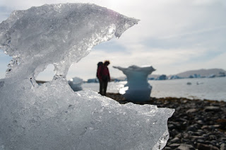
The pungent smell of sea and seaweed assails my nostrils and
a refreshing breeze blows in off the bay where flocks of seagulls shriek nosily above the icebergs. Several of these have beached and warrant closer inspection.
One almost as tall as me is mushroom shaped by the action of water when it was
at sea. All are melting rapidly in the strong afternoon sun. Every so often a
noise like a musket shot echoes round the bay as an iceberg calves. We sit
awhile to soak in the tremendous atmosphere before hitting the outskirts of
Narsaq.


A fishing settlement of just over 1,500 inhabitants,
Narsaq is situated on a plain at the foot of a 685 metre mountain named
Qaqqarsuaq which towers over the colourful weatherboard buildings which look like the spilled contents of a box of Quality Street. It’s a great feeling after slogging over some
of the roughest terrain imaginable to finally walk on a tarmac road and we make
good speed though the streets of brightly coloured houses looking
for the Narsaq Hotel where we hope to get a room.
A mustard yellow building finally looms into view, the flags
of Greenland, Demark and Iceland fluttering above it. Although there are no rooms available at the hotel, we are
in luck as there’s room at the nearby hostel the hotel runs. A large turquoise well
kept and well appointed building, we get a spacious room overlooking the
harbour with great vistas of the iceberg strewn Narsaq Sound.

The hotel runs a café come restaurant which is quite
bohemian, featuring white painted car tyres for tables, preserving jars
turned into lamps, and benches strewn with colourful scatter cushions. We join a cosmopolitan
crowd of tourists and locals for dinner as this seems to be the only joint in
town where you can get an evening meal. A large beef steak, chips and salad,
washed down by a cool beer, is much anticipated, but turns out to be something
of a disappointment. The steak is overcooked for our liking, the chips dry, the
salad limp and there are no Greenlandic beers available, only vapid Tuborg
lager beer which is cold if nothing else. However, I’m delighted to learn from
the owner that he is brewing his own craft ale named after Tugtupite, but
galled to discover that I have missed the first batch by a mere fortnight!!!
The following day we catch a ferry back up the picturesque
Tunulliarfik Fjord to Narsarsuaq which is the perfect end to a fabulous trip. From
the water we have the opportunity to spot some of the landmarks we had trekked
over and past during the last week. Although by no means easy, this
6-day 70 km trek was far less an ordeal than the one we did further south in
Klosterdalen, Tasermiut Fjord, as it has less dwarf trees to bushwhack through
and very few mosquitoes or midges. Moreover, it has fascinating history and
geology and the scenery is just as ravishing. With the added bonus of being
close to the international airport at Narsarsuaq which keeps the cost of
helicopter travel and/or boat transfers down, this route is a must for those
who wish to experience a truly memorable multi-day trek in the Greenland wilderness.


Watch our video of this trek at: https://www.youtube.com/watch?v=5fSwxha_wvg
Hello.
ReplyDeleteI like your trekking!!! Do you have the GPS track of your path?
Thank you for your blog!
Seb
France.
Hi Seb,
ReplyDeleteThanks for your message. The GPS track and description of our route can be found at Mountainviews.ie
http://mountainviews.ie/track/report/3107/
There is also a video of the trek at:
https://www.youtube.com/watch?v=5fSwxha_wvg
It's a great area for trekking and I hope you get there.
Best Wishes,
Sharron
This comment has been removed by the author.
ReplyDeleteHi Sharron!
ReplyDeleteThank you very much. I have see another your movie .... i like it!
I go in Greenland in august 2016 with 3 childrens (15, 17 and 18 years old) for 10 days in Kayak and 5 days in this trek.
Many thanks.
Seb
nb: I don't anderstand where i can download the track?
Click on this link for the GPS track and description of the route through Erik the Red's Land:
ReplyDeletehttp://mountainviews.ie/track/report/3107/
Perfect! Thank you!
ReplyDeleteSeb