Into the Wilderness
‘I can’t stand the heat,’ came the surprise answer to my
question as to why on earth a Spaniard would want to spend the summer up in Greenland . José is a jovial fellow who works for the
Tasermiut South Greenland Expeditions tour company through which we have
arranged a rib boat transfer up the Tasermiut Fjord to spend some days
wilderness trekking in a remote valley named Klosterdalen. He and numerous other
Spaniards head north to work for this company during the brief Arctic summer.
Each to his own I guess! Living in Ireland ,
where summer this year has been an even more complete wash-out than usual, hot and sunny Andalusia, where José hails from, seems infinitely more attractive than Greenland to me!
Perched awkwardly on the side of the bright orange rib boat
in an immersion suit which feels something akin to a straitjacket, our boat glides
out of Nanortalik harbour, the southernmost town in Greenland, which is located
on an island of the same name, that rather worryingly comes from the
Greenlandic, meaning ‘place where polar bears meet’. It soon picks up speed as
it races into the open waters of the freezing Arctic Ocean past icebergs the
size of houses, before turning into the Tasermiut Fjord. José assures us with a
chuckle that the chance of spotting a polar bear round here is next to zero,
but we should be more concerned about smaller life forms, in this case,
insects. How prescient his words were to prove…

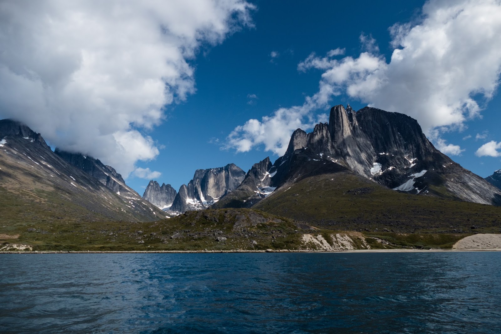
As we enter the fjord, our eyes are overloaded by utterly face
slapping scenery. Lofty mountains streaked with snow lift their granite heads
into a speedwell blue sky, shimmering waterfalls tumble headlong down vertical rocky
walls sculpted by glaciers that have laid bare their geology, and turquoise
rivers spill out of surprisingly verdant valleys. Salt laden wind streams
though my hair as the boat smacks its way across the petrol blue water shimmering
in the strong Arctic sunlight. I am suddenly overwhelmed by the exhilarating feeling
of freedom. We pass numerous icebergs in shades of turquoise and electric blue,
close enough to see the shady mass that lurks well below the water line and as
we progress deeper into the fjord, the landscape becomes increasingly wild and epic.
Rocky pinnacles thrust heavenward every way you look and I spot the iconic chimney shape of Ulamertorsuaq (The Great Cylinder), a 1,858 metre granite
monolith first conquered in 1977 and beyond it, Nalumasortoq, a distinctive
mountain that looks like an open book.
Some 60 km and almost 2 hours later, we arrive at the
seaweed strewn shoreline of the small beach at the entrance of the
Klosterdalen, so named as Norse monks founded an Augustinian monastery here in
the tenth century. I can’t imagine anyone wishing to live in such a wild and remote
place which experiences deep cold and short hours of daylight during the brutally
long Arctic winter. We disembark to words of encouragement and a cheery wave
goodbye from José. I watch with a feeling of mild euphoria as the rib boat speeds
off down the fjord, its roar and foaming wake receding until we are entirely alone
in this spell binding wilderness. Dreams are made of moments like this.

We struggle with our heavy backpacks up a steep gravel bank
to high ground which will ensure we are safe from any unexpected tsunami caused
by the calving of ice from the Sermeq glacier with its two prominent nunataks
which we can see at the head of the fjord. Amazingly, this huge wall of ice is
over 15 kilometres from us and over twice the height of the world’s tallest
skyscraper, the Burj Khalifa in Dubai, yet
looks not much further than a couple of kilometres, so clear is the Arctic air.

We find a level camping spot which offers breathtaking views
down over the fjord, the Sermeq glacier flowing down from the inland ice sheet and a near 360 degree panorama of
mountains which includes Ketil, a 2,003 metre granite monolith with a sheer
western rock face to challenge that of El Capitan in Yosemite or the Torres del
Paine in Patagonia, which have attracted some of the world’s top climbers.
Ketil has yet to achieve that level of international fame, as big wall climbing and adventure tourism
is still very much in its nascence here. We scour the area for wood which is surprisingly
abundant and comprised mainly of the bleached branches of dwarf willow, birch
and juniper, and, after erecting our tent, we settle in for the evening round a
roaring camp fire. As volleys of sparks ascend into a deepening blue sky, we scoff
a packet of dried expedition food and enjoy a wee dram of Tullamore Dew, purchased in Reykjavik ’s
duty free, to toast our arrival in this awesome wilderness. By degrees, the sun
descends lower in the sky casting a deep rose pink glow over the mountains at
the head of the Klosterdalen and catches the wispy cloud racing up over the
face of Ketil marshmallow pink. Although it is hot and balmy by day, anywhere
from 15-20 degrees Celsius, as soon as the sun sets the mercury plummets to
near freezing and we beat a hasty retreat to our tent.


The Blair Witch Forest and Battle
Deep mauve harebells nod in the cool breeze blowing off the
fjord as I slowly sip my coffee. It’s midmorning, the sun is warm on my back
and there isn’t a cloud in the sky. I feel mildly lethargic even though I have
slept like a log in the pure Arctic air, rocked into the arms of Morpheus by
the sound of the Uiluiit Kuua River which drains the valley we are about to
traverse. It’s almost midday when we break camp, faithfully following the route
marked on the 1:100,000 scale Tasermiut Fjorden-Nanortalik map by Harvey ’s
Map Services, Scotland .

Epic mistake! This map turns out to be worse than useless,
the route, clearly marked to the south of the Uiluiit Kuua River, leading us almost
immediately straight into dense, almost impenetrable stands of dwarf birch and
willow, most taller than a man. I struggle to remain upright as I clamber over
the gnarled and twisted branches of these trees which spread out along the
ground like malevolent tentacles. It's like something straight out of the Blair Witch Project! The heat and humidity is stifling in this
verdant prison, exacerbated by the fact that I have been forced to don a fleece
and a head net to protect myself against being bitten alive by millions of
midges and mosquitoes, attracted no doubt by the clouds of carbon dioxide we
are exhaling profusely as we strenuously bushwhack our way up through the
valley. In the midst of these trees it’s impossible to see exactly where we’re
going and the GPS does not give accurate readings. Broken branches suggest that
we are not the first to travel this way and this provides some comfort. The
trees don’t yield easily as we push our way forward, their spindly upper
branches clawing and snatching at us like demonic fingers. We are barely making
any headway at all, our passage impeded not just by the trees, but natural
obstacles such as small streams that cut deeply into the landscape and huge
boulders which we must find a way around. Two hours of this insufferable battle
with nature and I feel utterly demoralised and crushed. My wilderness dream begins
to evaporate and expletives replace my earlier euphoric utterances.
After what seems like an eternity, we emerge from this
hellish jungle bruised and filthy, our clothes holed and frayed, only to
encounter a new obstacle. Boot sucking bog. Living in Ireland , we
know all about bog, but Klosterdalen bog is like Irish bog on amphetamines! We make
painfully slow progress, sinking sometimes shin deep into its deceptively soft
mossy surface and before long my boots are soaked through despite my gaiters.
Laborious this might be, but the sight of acres upon acres of dense Arctic bog
cotton, ragged heads bobbing in the slightest of breezes is a sight to leaven
the spirits of even the weariest trekker.

Bog now gives way to ever more squelchy marshland and then a
couple of lakes. The map instructs us to take a course round the southern edge
of the first lake, the reedy shoreline of which we attempt to follow in order to
avoid another dense area of trees. I almost fall into the water with fright as we startle a
duck which takes off noisily in a flurry of feathers! However, we soon encounter numerous
small streams too wide to jump, which forces us back into the evil arms of the Blair Witch
Forest
Martin frees me and we struggle on up the shoreline of the other lake, finally emerging into
yet more bog. Tired by now from all the bushwhacking, my pack feeling much
heavier than 18 kilos, I trudge along in the mossy morass only to find myself keeling
over as I suddenly sink knee deep. Unable to free myself, I flap and flounder
like a snared waterfowl until Martin once more comes to my rescue, giving me an
almighty tug. The bog releases me with a disgusting sucking sound. I’m now completely
soaked to the skin down my left side and we immediately look for a passage out
of this boggy terrain, making our way towards the river where we are relieved
to find some areas of compacted gravel.

Although faithfully following the route marked on the map, we have made painfully slow progress through the wretched terrain of this valley, moving barely 1 km an hour, and as our intended route takes us across the Uiluiit Kuua River, which we simply don’t fancy in our present state of mind, we’re both ready to call it a day. We traipse a bit further upriver where we find a suitable flattish spot near a large fin-shaped granite boulder above the river bank and set up camp. I retreat into the tent almost immediately to get away from the midges and mosquitoes and to remove my wet clothing and boots. To my horror I discover that I have been bitten right along the line of my knickers on both buttocks, an area to which I had not applied any repellent and that is now itchy, throbbing and inflamed. I take an anti-histamine to prevent the allergic reaction I know will surely worsen if untreated. Mosquitoes can bite right through certain material making it essential to either wear more than one layer or to lather your skin in repellent. I deeply regret that we did not treat our trekking clothes with Permethrin before we came to
Martin brings me a cup of hot ginger tea which lifts my
spirits a little. A packet of freeze dried macaroni cheese tastes divine and I
greedily scoff the lot. Feeling warm and much more comfortable, I now gaze
through the netting of the tent and soak in the majesty of our surroundings. We
have this lonely, chocolate box pretty valley far from civilisation entirely to
ourselves. We are hemmed in by impressive 1,000 metre plus snow streaked mountains
which seem to be bearing down on our tiny tent, lost in the enormity of it all.
A thrill runs through me. Martin lights a small camp fire, we enjoy another
tipple of our whiskey and watch the mesmerising spectacle of the surrounding
mountains turning ruby red as the sun goes down.

River Deep and Mountain High
It’s around 7.30 am when I awake to what sounds like light
rain on the tent. My heart sinks. What a misery it will be to trek uphill today
clad in bloody GoreTex! However, we unzip the exterior tent flaps to see the
mountains draped in veils of mist, no rain. We soon discover that the sound is
caused by thousands of insects hitting the canvas and I can see
the depressing shadow of scores of mosquitoes that have settled on the inner
tent below the flysheet where they are lined up like MiG fighters ready for
another day of warfare! On goes the
repellent.
Martin lights our Honey stove to boil water for coffee and a
freeze dried meal which we have to consume inside the tent, as the swarms of
midges make it impossible to eat or drink outside. I can’t say I’m looking
forward to today all that much, as we have to cross the Uiluiit Kuua River
before we commence a 600 metre climb to a col above this valley through terrain
that looks every bit as brutal as that we covered yesterday.

Weak sunlight is beginning to filter through the churning
mist as we break camp. It’s going to be another hot, sunny day. We set off up a
rocky scrub covered bank of moraine to avoid the worst of the bog and head towards
a spot just over half a kilometre away above the confluence of the Uiluiit Kuua River and a stream coming down from the col. We aren’t accustomed to river crossings in Ireland and I
approach this one with a degree of trepidation. Being quite early in the day,
the river level is at its lowest and we scan the banks looking for a safe place
to cross where the water is not too deep or fast flowing and has not undercut
the bank. We settle on a 20 metre section with a gravel bank midway across which Martin tests before I sally forth. Removing
my boots and socks and putting on a pair of crocs, I roll up my trouser legs, unbuckle my
rucksack and, with my boots hanging round my neck, step tentatively into the
chalky turquoise water. The cold instantly hits me like a sledgehammer! We move
as quickly as possible diagonally downstream through the water which is knee deep in
places. The cold is so intense it seems to be biting into the very marrow of my
bones and I am relieved when we safely splosh out onto a sandy bank on the
other side.

Re-booted, we now begin the climb uphill towards the col. We
soon run into yet more dense patches of dwarf trees that obscure numerous
boulders comprising terminal morraine that are very tedious to traverse. As we ascend, we gradually pass out
of the trees and keep away from the stream bed where the vegetation is
thickest, opting for higher scrubby ground comprised of shin high dwarf willow
and birch, bilberry, crowberry, juniper and Labrador
tea, which sends out a pleasant aromatic smell when brushed against. We see numerous
large brown mushrooms and deep purple berries on the juniper, crowberry and
bilberry bushes. The crowberries are watery and relatively tasteless, but the
bilberries are incredibly sweet.
Higher up, the scrub becomes ankle high interspersed with
grass and we spot many angelica plants with large globular flower heads. Angelica
has a strong perfumed scent, reminiscent of anise, musk and orange and all
parts of the plant are edible. As we approach the snow line, we notice patches
of Arctic thyme, the pale pink flowers enlivening the landscape as well as the
odd blue gentian. Small green shoots are beginning to sprout amid black and
decaying swathes of last summer’s vegetation only just emerging from beneath patches of
dirty snow which is slowly melting. Spring has come late here.
The pestilential swarms of midges have now subsided in the
cooler air and we stop by a small stream running beneath a boulder the size of
a house to fire up our MSR stove for lunch. Removing my head net is bliss; the breeze
instantly cools my sweaty face and I can see the immense beauty of the landscape
clearly and not through a net, dimly!
Bellies full, we now head upwards through a boulder field
which requires care and attention so as not to fall or to succumb to a lower leg injury.
The rocks are angular and sharp to the touch, sporting rough desiccated brown lichen
which scuffs our hands and many of the smaller ones wobble dangerously as I put
my weight on them. Eventually, the ground begins to level out and we arrive at
the col. A small stream of the purest water runs through it and nearby is a
grassy level area that serves as a crude bivvy spot with low rocky walls
offering shelter from the wind and grandstand views down into Klosterdalen and
of the Ketil massif opposite. A more perfect camping spot cannot be imagined!

We lie in our tent resting and gazing at the iconic
granite monoliths opposite. This part of Greenland has been dubbed the new Patagonia for good reason. The massive 2003 metre high northwest
face of Ketil which boasts a vertical granite wall over 1400 metres (the
highest big wall on the globe) has probably only been climbed by a few hundred
people since its discovery in the 1970s.
The shadows begin to lengthen as we make our way the few
hundred metres down from the col to a deep blue lake nestled in a barren, rocky
amphitheatre surrounded by huge spines of mountains that resemble the armoured
plates on the back of a prehistoric beast. The winter this year was
particularly hard, betrayed by the fact that the lake is still partially frozen
and snow lies feet deep on its western shoreline. A lack of boot prints makes
it clear that no one has been through this col yet this summer. We sit on a
granite boulder, sipping whiskey and watching the soft white cloud boiling
about the mountain tops and sailing across a periwinkle blue sky. A feeling of
utter serenity washes over me and it’s only when the intense cold emanating
from our makeshift seat begins to make me feel decidedly chilly, that we
retreat to our tent to eat dinner and to watch the sunset over Ketil.

Sipping mugs of hot, spicy ginger tea, we watch long shafts
of hazy sunlight radiate sideways into the valley from behind the Nuussuup
Qaqqaa mountains across the other side of the fjord, its water shining like
liquid mercury. All the small streams, the river, wetland and lakes are luridly lit in the glassy light, clearly illuminating how wet and marshy the valley
bottom is. By degrees the cloud above Ketil turns smoky grey and apricot and
the western sky beyond Nuussuup Qaqqaa screams vermillion, chrome red and saffron
yellow where the sun has set. Ketil responds by blushing deep orange and blood red,
before fading through chalky mauve to steel grey. The light show over, I fall asleep to the melodic
gurgle of the small mountain stream nearby.


Retreat to Klosterdalen
A near full moon is sinking in a clear blue sky behind
Ketil. It’s going to be another scorcher. Today is decision time. We have
sufficient food for several more days in the wilderness, but our insect
repellent is dangerously low. Moreover, the time we have taken to reach the col
means we have fallen behind our estimated schedule. If we decide to pass over
the col we are committed to pushing on towards Qinnguadalen, another valley
which is still some days away, and my knees don’t feel too good. The weather
forecast, obtained daily from Martin’s DeLorme Inreach two way satellite
device, which indicates a föhn wind is highly likely within the next 48 hours,
clinches it. We decide to descend to Klosterdalen rather than be caught out on
the high mountain passes where we would be forced to sit out this strong wind
which blows off the ice cap sometimes for around two days, which would mean
missing our helicopter flight back to Narsarsuaq. We send a message to José to
tell him to collect us at the beach at low tide the day after tomorrow.

I can’t say I regret our decision, because although the
landscape is magnificent, we are no longer beguiled by its beauty. The sheer
volume of insects coupled with the roughness of the terrain have made life at
times unbearable. Martin, who is not allergic to mosquito bites, has a back peppered
with literally thousands of livid purple marks! I am at a loss to know what the
millions of female insects, who require a blood meal to gestate their eggs, prey
upon, for apart from a handful of snow buntings, lapland longspurs, ravens and a solitary
duck, we have seen no fauna at all. As we begin our descent from the col mid
morning, mercifully in the shade of the mountains, we spot an Arctic hare
sitting upright amid some boulders, it’s white fur providing surprisingly good
camouflage. Suddenly aware of our presence, it hops off before we can commit it
to camera. I guess the hare has not been spared by the midges and mosquitoes
either!

Just below the snowline where we pass into brilliant hot
sunshine, the midges begin to swarm around our heads and we are forced to don
the dreaded head nets. Descending from the col is no easier than the ascent,
although we have a better idea of the terrain and what obstacles to avoid.
Higher up, we stick to the stream, but as we encounter the boulders and dwarf
trees lower down, we keep to the scrub as much as possible which is mostly shin to thigh
high. In the clearings, I am surprised at how dry the ground is, with large
patches of desiccated lichen that has dried in characteristic hexagonal shapes,
and we later learn that this summer in Greenland
has been particularly dry. With plenty of time, we decide to cease our battle
with the trees and rocks and stop at the hottest time of day in the shade of an
enormous boulder where it's pleasantly cool, for a well earned nap.

It’s mid afternoon when we approach the river which to me sounds
louder. We discover that the snowmelt from the nearby glaciers has swollen it’s
waters which are at least a foot higher in places. The gravel bank is submerged
and the freezing water is now well over my knees soaking my trousers. I’m relieved
when we scramble up the opposite bank. We decide to use the same camping spot
again and, with the tent erected, begin the task of foraging for firewood. Once
lit, I sit by it to dry my trousers. Insects are usually repelled by the
presence of smoke, but the midges and mosquitoes here don’t seem to be deterred
much at all, or maybe it’s just the sheer volume of them? Once the midges
subside as the temperature falls, we eat a freeze dried meal of chicken korma with rice. Our roaring
camp fire eventually burns down to a few glowing embers just as the sun finally
fades from the valley, making it decidedly chilly. We retire to the warmth of
our sleeping bags as the first stars appear in a cloudless night sky.


Down by the Riverside
The penetrating musty odour of the bog wafts in through the
tent flaps along with scores of mosquitoes as Martin hands me a mug of coffee. I
rise to a view of swathes of white mist hovering above the valley which merges with the acres of white bog cotton, so it’s almost impossible to see
where the two meet. It’s an uplifting sight. Mid morning we break camp and
begin the trek down through the valley towards the beach. The thought of having
to bushwhack our way through the horrible trees yet again is playing on my mind.
Avoiding the bog as much as possible, we follow the river downstream, walking
on the flat gravely banks and channels surrounding it where clumps of brilliant
pink flowers grow profusely. Dwarf fireweed (Chamerion latifolium), in Greenlandic niviarsiaq, which means ‘little girl’, is Greenland’s national
flower, and provides valuable nutrition for the Inuit, who eat the leaves raw,
boiled with fat, or steeped in water for tea. The flowers and fruits are
consumed raw as a salad with meals of seal and walrus blubber.


We soon come to the two lakes, and after walking down the shoreline of the upper one, discover a bridge of land between the two. We immediately see that it’s possible to avoid bushwhacking our way
through the dense trees above the shoreline of the next lake, the route marked on the Harvey map, by crossing this bridge to walk down the other side which is vegetation free. It is becoming increasingly obvious to us that the map has not been 'ground-truthed' and is woefully inaccurate. The new way we follow is flat and boggy, with rust red
patches denoting the presence of bog iron, but it’s pretty firm and we make good
speed on this section. If only we knew this on the way up, but the landscape looked as if it was just wetland and thus impassable. The sight of acres of bog cotton quivering and dancing
in the breeze, so dense it looks like snow against the clear blue sky, is stunning.
I’ve never seen such a display. Arctic bog cotton is thicker than the common
cotton grass we see in Ireland
and as we move through it, tiny clumps and filaments rise upwards, catching the
sunlight like incandescent candle flame, before being carried away in the
breeze.


We follow the course of the turquoise river flowing languidly through the flat valley bottom past colourful patches of Arctic thyme, enjoying the ripples etched in its golden sandy banks, until our progress is abruptly impeded by a water channel leading into it which is too deep and wide to cross. As we are trying to find a way to surmount this obstacle, Martin receives a message from José saying that the föhn wind is expected later today and he is leaving Nanortalik now to collect us. We have just a couple of hours to reach the beach! Unable to cross the channel, and now running short of time, we decide the best way forward will be to completely ignore the useless Harvey map and to follow the river down rather than re-enter the Blair Witch Forest! We don’t bother to don our crocs, and in our boots and gaiters, plunge into the water. It doesn't feel all that cold and we meander our way round huge boulders, scramble over rocks and wade through narrow channels where the water comes over our knees. I am really enjoying this challenge, but it might not be advisable when the river is in spate in early summer.


We follow the course of the turquoise river flowing languidly through the flat valley bottom past colourful patches of Arctic thyme, enjoying the ripples etched in its golden sandy banks, until our progress is abruptly impeded by a water channel leading into it which is too deep and wide to cross. As we are trying to find a way to surmount this obstacle, Martin receives a message from José saying that the föhn wind is expected later today and he is leaving Nanortalik now to collect us. We have just a couple of hours to reach the beach! Unable to cross the channel, and now running short of time, we decide the best way forward will be to completely ignore the useless Harvey map and to follow the river down rather than re-enter the Blair Witch Forest! We don’t bother to don our crocs, and in our boots and gaiters, plunge into the water. It doesn't feel all that cold and we meander our way round huge boulders, scramble over rocks and wade through narrow channels where the water comes over our knees. I am really enjoying this challenge, but it might not be advisable when the river is in spate in early summer.


Just under a kilometre later, the terrain begins to drop
slightly, the speed of the water increases, the river channel narrows and we
are forced to climb to higher ground. With hindsight, it might have been better
to have crossed the river to the opposite bank where the vegetation seemed to
be less dense and then recrossed it where it flows across the beach into
the fjord as it was low tide. Instead, we scale a granite outcrop and then descend
and bushwhack our way through a couple of hundred metres of dense dwarf trees in
clouds of midges and mosquitoes, before we finally emerge into the scrub land
behind the beach.
Arriving above the beach, we see there’s no sign yet of José, but a large yacht is anchored offshore which we ascertain belongs to a
Norwegian climbing group who are probably tackling Ketil. Knowing that we will
soon leave this place, I remove my head net, glad for the cool breeze blowing
up the fjord which banishes the insects and sit quietly for some time just soaking in the atmosphere. A
nearby clump of harebells nod joyously in the breeze and tiny waves lap at the
seaweed laden shore. I feel slightly remorseful that we do not have another
night here as we had expected.


Before long we hear the tell tale hum of a rib boat. The
tiny figure of José waves and we make our way down to the beach. On the boat,
finally away from the pestilential clouds of insects that have so plagued our
trek, my thoughts drift to a real meal, a hot shower and cold beer, not
necessarily in that order! The journey back up the fjord facing into the wind however
is brutal. Although I’m in an immersion suit, the fact that my feet and legs
are still wet from being in the river means I’m chilled to the bone. The wind
and salt spray burns my face and my misery only increases when we enter a bank
of clammy fog near the top of the fjord. Nanortalik can’t emerge through the
gloom quickly enough!
Watch the video of our trek at: https://www.youtube.com/watch?v=fFihqt587gs
Great to read the blog and experience the trip through your eyes. A lovely video of the trip too. It was good to meet you guys out there. I hope you enjoyed the remainder of your trip after seeing you back in Narsarsuaq.
ReplyDeleteHarsharn
Hi Harsham! Thanks so much for your kind words. We were up in Mellem Landet and saw your plane to Copenhagen fly over the day after we last saw you! The rest of our trip was somewhat more relaxed, with a pleasant mini cruise up the coast from Nuuk to Illulisat where we enjoyed a day's ambling round the ice fjord. Glad you liked our video of Klosterdalen, a place we certainly won't forget in a hurry! It was lovely meeting you too, Harsham.
ReplyDeleteTake Care,
Sharron :-)
This sounds and looks so great, thanks so much for sharing! I'm planning on going to Tasermiut Fjord next August and I was wondering what was exactly your route. Did you hike all the way to Tasiusaq or were you dropped off at Klosterdalen and hiked around that area for a bit and went back by boat? I'd really appreciate some advice, thanks so much,
ReplyDeleteNicola
:)
Hi Nicola, I thought our route was explained quite clearly in the above blog: we were dropped off at the beach at Klosterdalen by rib boat from Nanortalik, and then hiked up to the col and lake at the head of the Tupaassat Valley. From there we returned to the valley floor and made for the beach at the entrance to Klosterdalen to avoid being caught out in a föhn wind. A downloadable GPS track is given at: http://mountainviews.ie/track/report/3102/
ReplyDeleteHope this helps and enjoy Greenland. Just make sure you have sufficient insect repellent...
Thanks so much for your quick reply! I was a bit confused as to how far you hiked and whether you returned back to Klosterdalen or somewhere else, but this makes it clear. Thanks so much and thank you especially for sharing all of it, it's a great source for inspiration! :)
DeleteNo worries, Nicola. Glad to be of help. Just be aware that Klosterdalen is brutal and pathless, choked with dwarf trees, bog, fenland and higher up, huge boulder fields. Progress is painfully slow so allow yourself plenty of time. See our video at: https://www.youtube.com/watch?v=fFihqt587gs
Delete