Pages

Pages

Tuesday, 9 June 2015

Mulhacén: King of Mountains, Sierra Nevada, Spain

The Sierra Nevada soar into an impossibly blue sky above the ancient city of Granada. They are living up to their name all right: snow capped, they gleam in the hot spring sunshine. It’s mid May and I’m in Andalucía, the former Moorish kingdom of Al-Andalus in southern Spain. Everything here appeals to my senses: the melodic language; the warmth of the Spanish sun; the sun-kissed coastline bathed by the warm waters of the Mediterranean; the high, narrow streets of ancient cities, their whitewashed buildings clustered around crumbling fortresses on hilltops that rise above rolling plains; the Arabesque architecture with its intricate zellij tile work and dripping alabaster that reaches its apogee in the magnificent Alhambra Palace of Granada; the incredible gastronomy with more than a nod to the region’s Moorish past; the divine wines and craft beers; the passion of flamenco guitar and above all, the palpable sense of history that emanates from the very ground. Granada is the resting place of two of Europe’s most remarkable rulers: the Catholic monarchs, Ferdinand and Isabella, who, in the dying years of the fifteenth century, united the kingdoms of Castile and Aragon and reclaimed Granada, the last bastion of the Moors, for Christendom. This seismic event created a fertile seed bed from which grew an assertive, expansive new Spain that set its sights across the Atlantic, paving the way for the Conquest of the Indies and the birth of a global empire which has left its mark on countless countries and peoples across the world today. I simply love Spain, and the southern part of it in particular.


This brings me back to the Sierra Nevada, the mighty mountain range that straddles the provinces of Granada and Almería, formed 66 to 1.8 million years ago during the collision of the African and Eurasian continental plates. I have long harboured a desire to climb the highest mountain in my favourite European country, which is what has brought Martin and myself here. We have our sights set on Mulhacén (3,482m), the highest peak in Europe outside the Caucasus Mountains and the Alps. Its also the third most topographically prominent peak in Western Europe (after Mont Blanc and Mount Etna) and ranked 64th in the world by prominence. Being in Andalucía, it is no surprise to discover that Mulhacén has a Moorish connection: it is named after Abu I-Hasan Ali, or Muley Hacén, as he is known in Spanish, the penultimate Muslim King of Granada who died in 1485 and, according to legend, was buried on the summit of the mountain that came to bear his name.

Although it’s only around 9.00 am, the sun is surprisingly hot on our shoulders as we leave the Albergue Universitario at Peñones de San Francisco, a mountain lodge run by the University of Granada. We are the only people staying here, but just a fortnight earlier the place would have been bursting at the seams with skiers and snowboarders eager to enjoy the last of the winter snow. Now, the large car park at Hoya de la Mora and the vast ski village sprawling across the mountain slope below surrounded by retreating patches of dirty snow and motionless ski lifts, are eerily deserted, as desolate and bleak as a northern England seaside resort in mid-winter.


We climb steadily uphill passing by the triangular masonry shrine to the Virgin de las Nieves under a powder blue sky streaked by wispy white cloud. Here and there we spot bright patches of spring flowers, welcome dots of colour amid the stony, arid landscape. We follow a thin trail, worn bare by the passage of countless feet, that undulates its way ever upwards, occasionally crossing an asphalt road, the highest in Europe, that switch backs its way towards Posiciones del Veleta (3,100m). Taking this trail rather than following the road cuts off some 5-6 km. In the summer months, the Sierra Nevada National Park authority runs a mini bus service to Posiciones del Veleta from where people make the short climb to Veleta and the more adventurous set out for its twin peak, Mulhacén.

Less than an hour into our climb, a silver haired man in shorts with heavy pack coming down the trail hails us loudly. I instantly recognise the accent as being from the South East of England. He relates how he and his group climbed the mountain yesterday and have just spent the night at the Refugio de la Carihüela. “It’s a bloody long way”, he says, brow furrowed, shaking his head, when we inform him we're planning to summit and return the same day. Doubts began to crowd my mind as ‘Jeremiah’ describes in great detail how much snow was encountered, the debilitating effects of the altitude and the time it took his party to summit. Moreover, this was their second attempt – last February they had failed in their task due to the alpine conditions. I felt somewhat deflated as we walked away and wondered whether it was wise to try and climb Mulhacén in one day. Perhaps we should have stayed overnight in one of the refugios too…

The trail weaves its way along the top of the Barranco de San Juan, at times hanging perilously close to the edge of this rugged ravine where one slip could result in a fatal fall. As we ascend, we pass the rest of Jeremiah the Englishman’s group slowly making their way downwards leaning heavily on their walking poles and grumbling loudly about the distance and the steepness of the terrain. Mountain gazelles these are not! We soon spot the Sierra Nevada Observatory and the white dish of the IRAM radiotelescope and around 3,000m encounter the first snow, which lies feet deep on the road, slowing our progress. Below us is the partially frozen Laguna de las Yeguas. As we approach the Refugio de la Carihüela, we disturb a herd of ibex that are perfectly camouflaged against the rocky terrain; they melt away as soon they spot us. The refugio is just as well camouflaged, a low semicircular structure constructed of the surrounding rock that blends perfectly with the landscape. Outside are two other trekkers, a couple of Swedish brothers, who are also aiming for the summit in a day. At least we are not the only fools to be attempting this! We have reached the refugio in around two and a half hours from the Albergue. But it took Jeremiah nearly that much time to cover the distance from the refugio to the point where he met us on the trail. Read into that what you will!


We sit on the stone benches in front of the refugio soaking up the view towards distant Mulhacén and the even more distant peak of La Alcazaba. My eye follows a thin white line where snow lies on a gravel track, the old Sierra Nevada road, once drivable but closed to traffic in 1999, that leads towards Puerta, a gap below the Crestones de la Río Seco which do indeed resemble the comb of a cockerel, angled sharply upwards into the hazy sky. Beyond, the old road weaves its way round Loma Pelada behind which Mulhacén towers. It does indeed look a bloody long way off! The atmosphere is full of Saharan dust, giving the landscape, which appears sharply etched, an odd, glassy hue. The dust has also trapped the heat, making the day abnormally hot for the time of year and we are extremely warm in just short sleeved woollen base layers. Despite the heat, large snow patches dot the bare brown mountain slopes and we can see that the route crosses several of the steepest of these. Fortunately we had the sense to pack a set of half crampons. Suitably rested and refreshed, we set off following the tracks made by the Swedes who are several minutes ahead of us.

The snow is soft and sugary and I’m instantly glad of my crampons as I traverse the steep snow covered slope leading away from the refugio. Below this we follow the old road as it makes a couple of hairpin bends below a large outcropping shelf of rock where water is cascading down from the melting snow above in a series of mini waterfalls. Below the old road we spot the small Laguna de los Vesares swollen by the snowmelt. There now follows a long plod across snow and scree slopes towards Puerta, a nick in the rocks between the crags of the Crestones de Río Seco and the equally rugged Raspones de Río Seco. Through a gap in the Crestones, we shudder at the vertiginous drop into the blue-green Valdeinfiernos valley.


Passing through the narrow, snow choked cleft of rock aptly named ‘Puerta’, another vista more barren than ever unfolds before us, with the old road clearly visible as it sweeps round the bare and lifeless Loma Pelada. The cluster of small tarns named Lagunas de Río Seco that should be visible below the old road are completely buried beneath snow, their presence only betrayed by the slightest depressions and hint of aqua. With the exception of the snow, the landscape reminds me of a scene from Mars, made all the more Martian by the strange light caused by the dust in the atmosphere which affects the Rayleigh scattering, so that the sky does not appear to be very blue.

We stop to remove our crampons as the worst of the snow is now behind us. We decide to follow the old road rather than take a path shown on our map that traverses the ridge above the Luguna de la Caldera, as we are not sure how steep and snow covered the terrain is above the lake. Although this adds a couple of extra kilometres to the route, we feel it is better to be safe than sorry and make good speed round the snow-dappled basin, Cuenca de Río Seco, below Loma Pelada. Where the road turns sharply downhill towards Laguna de la Caldera, we pass a small rectangular building perched on a shelf of rock with fabulous views down the Seco valley which we later discover was the Refugio Pillavientos. We finally spot the Refugio de la Caldera, which, like the Refugio de la Carihüela, is built of local stone and is therefore almost invisible against the barren landscape.


As we approach the refugio, we pass several small patches of white rock rose (Helianthemum apenninum), the first flowers we have seen since we hit the trail above Hoya de la Mora. Between the refugio and a small lake are a herd of Spanish ibex, several sporting impressive sets of curled horns, that seem totally unperturbed by our presence. We arrive to find the Swedes eating their lunch. The refugio inside is identical to Carihüela: two wooden sleeping platforms one above the other running the width of the building, and a long wooden table with benches either side complete the furnishings. A series of hooks run along one wall for hanging up clothes, there are some candles on the table and, for a well-used remote refugio, it’s fairly clean and comfortable.


Martin fires up our gas stove for lunch and I potter off down to a small lake fed by snow melt. In the summer this will disappear, but today the surrounding patches of snow are reflected in its shallow green water, above which Mulhacén rises majestically. We have a steep climb of over 400 metres ahead of us so we fill ourselves up with a highly calorific meal of freeze dried food.

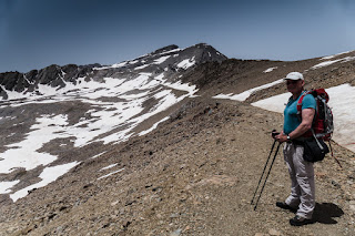
Until now the route has been fairly benign, mostly consisting of a gentle upward ascent. All that changes as we begin the slog up Mulhacén. The sun is beating down relentlessly as we pass by the Laguna de la Caldereta and commence the ascent of the dusty trail up the western flank of the mountain. The heat, trapped by the dust in the atmosphere is suffocating and I can feel it being reflected off the rocks and bare soil as I struggle upwards. I worry for Martin who does not like the heat at all. He’ll suffer making this climb at altitude and he has already slowed considerably. Although we did expect there to be snow on the higher ground, neither of us predicted such unseasonably warm weather and for it to be in the mid-twenties over 3,000m high!


We push on ever upwards crossing a couple of patches of dirty snow clinging stubbornly to the trail. Here and there, tufts of wiry yellow grass break the monotony of the stony landscape and I am delighted to spot some clumps of Viola crassiuscula, the Sierra Nevada violet, endemic to this mountain chain, flowering amid gaps and crevices in the bare rock. The pretty mauve and white flowers dance in the breeze on their delicate stalks and seem curiously out of place in this bleak and arid landscape. I stop by these to wait for Martin slogging his way upwards. The Refugio de la Caldera is but a minute dot barely visible above the two, now tiny, metallic green lakes we had passed by earlier. The larger of the three, Laguna Caldera, was not visible at the level of the refugio and is still hidden under ice and snow, nestled in the bottom of the scalloped basin below the shattered rocky ridge of Puntal de la Caldera. Beyond, Veleta shimmers grey blue in the heat haze. Another party of climbers now appears about a hundred metres below us amid the shattered rocks on the steep side of the Loma del Mulhacén. Their progress is also painfully slow in the fierce heat and altitude.


I mop the sweat from my brow and suck the last vestiges of water from my bladder and we begin the final push for the summit, passing the Swedes who have begun their descent. With their words of encouragement echoing in my ears, we cross a deep patch of sugary snow and are at last atop the broad rocky ridge leading to the summit cairn. This finally comes into view, a small outcrop standing a couple of metres higher than the surrounding rock, sporting a concrete pillar and what looks to be a gated shine carved out of the rock which is covered in scarves and items of clothing that have been tied on to the metal grille, including a rather garish bright orange tee shirt. It’s almost impossible to see what’s inside the shrine due to the clutter, but I think I spy the Virgin Mary amid the candles, bottles, plastic flowers and wooden crosses, devotional offerings left by umpteen climbers.


After the obligatory summit photo, we take some time to admire the view, clambering the final couple of metres onto a concrete platform sporting the concrete pillar. When the weather conditions are right, the views over the Sierra Nevada are extensive, and it’s possible to see more distant ranges including the Sierra de las Nieves north of Marbella, the Sierras de las Cazorla to the east of Jaén and even the Rif Mountains in northern Morocco. But today we cannot see much beyond the immediate mountains, let alone Morocco, as Africa has instead come to us in the form of Saharan dust! But standing on the highest point in peninsular Spain is a great experience, even on this dusty, heat hazed day, and my stomach churns as I eye the near perpendicular 500 metre plus drop to the snowy Hoya del Mulhacén with its ice encrusted lakes, and admire the broad sweep of the sharp ridge above the diminutive Refugio de la Caldera standing proud, pimple like, from the ruddy, parched face of the landscape. The rocky ramparts of nearby Al Alcazaba rise majestically, a rectangular, unroofed stone walled building, apparently once a chapel, stands sentinel near the summit, while in a valley far below, tinged the faintest of green, is a long thin lake, the final of seven in the Cañada de las Siete Lagunas.


It’s a very long way back to the Albergue where we have left our car, and mindful of the time this will take, we pull ourselves away reluctantly from the roof of Spain, stopping briefly to take photos for the climbing party we saw earlier, a group of young Spaniards who have just arrived at the shrine. We progress speedily down towards the Refugio de la Caldera, taking care not to slip on the trail pounded to bare earth by the passage of countless feet. Before long we are back on the old road sweeping between the two metallic green lakes we saw from the summit and we’re soon approaching the bend above the Refugio Pillavientos. Upon rounding the corner, I feel slightly deflated looking at the distance we have to cover to pass through Puerta let alone that to the Refugio de la Carihüela, a tiny protuberance in the pass between Veleta and the Tajos del Tesoro. I can see the Swedes crossing over the first patch of snow ahead of us, but poor Martin is still struggling with the heat so we move more slowly than we otherwise could do. Coming to the snow, we stop to don our crampons. Hair stiff with sweat and dust, I’m now totally out of water and looking forward to a good drink at the waterfalls we passed earlier. The sun is sinking lower in the eastern sky, it isn’t quite as hot now and I can see ahead that some of the route lies in shade which will make the going easier for Martin.


After what seems like an eternity, we come to the small waterfalls beneath the almost sheer southeast side of Veleta where Martin, suffering from mild heat fatigue, cools down in the crystalline cascade. The water is freezing but tastes divine to a sun parched, dusty mouth and throat! Now out of the sun and refreshed by the water, we move rapidly up the snow slope to the refugio. Here we remove our crampons before setting off towards the tarmac road down to the Albergue. Rounding the corner from the refugio, an incredible vista unfolds of the Tajos de la Virgin snaking away to the south-west, but we are instantly blasted by a very chilly wind and stop to put on our Rab generator smocks for the first time. As we descend along the trail, the white dish of the IRAM radiotelescope is silhouetted against a sky turned orange and apricot in the setting sun, hanging in the dust laden atmosphere like a Chinese lantern. Underneath this magnificent sky, an endless sea of brown peaks streaked with snow retreat into the distance, fading to smoky grey and sepia before being swallowed in the haze.


Night falls as we are about a kilometre from the Albergue and far below on the darkening plain, I spot the shimmering pin points of thousands of lights betraying the location of Granada some 25 km away to the northwest. We arrive back at our car in one hour 50 minutes from the refugio, after completing the summit attempt in about 13 hours, covering over 30 kilometres with some 1,500 metres of ascent, despite Jeremiah the Englishman's doubts that this could be done! Two hours later we are sitting, showered and refreshed, in a plush hotel suite in Granada sipping a delicious cool Mammoth Granada Imperial Stout and wolfing down a selection of tasty tapas. I walk out onto the balcony, the ceramic tiles beneath my bare feet still warm from the sun, and stare towards the Sierra Nevada, snows silvered by the light from a hazy crescent moon and a scattering of stars that float above their jagged peaks. The night is still, serene, the scene mystical, magical, like something from the pages of the Arabian Nights. Indeed, it almost seems that the crescent moon, symbol of Islam, is pointing towards Mulhacén, the final resting place of the penultimate Moorish King of Al-Andalus, a mountain truly fit for a king, whose summit we have just conquered.

Watch the video of our climb at https://www.youtube.com/watch?v=Wui0tQR5Hjk

Thursday, 16 April 2015

Trekking and Wild Camping in the Brandon Massif, Dingle Peninsula, County Kerry

Cloghane to Masatiompan

Mist floats above the retreating waters of the creek through which the Owenmore River empties into Brandon Bay, laying bare huge swathes of gleaming wet bladder wrack seaweed. From somewhere out on the mud flats beneath the rolling mist, the haunting, plaintive call of curlews drift ashore. The mid-morning air is crisp and pungent with the briny smell of the ocean and a glassy luminescence cast by the sun almost breaking through the white blanket of mist lends something of an ethereal atmosphere to the chocolate box pretty village of Cloghane, a thin thread of colourful houses built along the shoreline at the southern end of the creek.

We have just stayed overnight at the excellent Mount Brandon Hostel, run by a gregarious and wonderfully welcoming lady named Mary, and, after regaling ourselves with a wholesome Irish breakfast, we set off along the road weaving its way above the creek towards Cappagh to begin a three day trek of the Brandon massif. Our objective is to road test items of our camping kit in preparation for some wilderness trekking we are planning overseas later this year. Consequently, we are each burdened with very heavy rucksacks, and, on this Easter weekend, somewhat fittingly this is a cross I simply have to bear!

The promise of a fine day has brought out numerous people of this small community who greet us cordially with waves and cheery smiles as we pass along the road, stopping every so often to admire the fine vistas of the creek flashing in and out of the moving mist and tantalising glimpses of the golden sandy arc of Fermoyle Strand and the rising ground to the east. Signs of spring are everywhere. Crows are nesting noisily in the bare upper branches of the trees eyed by nervous wood pigeons and song birds flit from branch to branch, their elaborate vocalisations filling the air. The hedgerows are speckled with brilliant dots of colour, betraying the presence of celandines, wood cranesbill, wild strawberry, primroses and violets that are shaded by the boughs of trees sporting the pale green buds of new leaves, plump pussy willows and misty white blackthorn blossom.


We turn inland towards An Teer, crossing an old stone bridge over the rushing waters of the Owennafeana River to confront a rolling patchwork quilt of small brown and green fields dotted with farmsteads sweeping up to the very feet of the mountains beyond. Vapour, lifted from the sea and borne inland on the slightest of breezes, is settling on the tops of the mountains, obscuring their peaks. The heady, sweet perfume of gorse, blazing golden yellow, hangs in the stillness of the morning air, and, behind the crumbling stone walled hedges in tiny paddocks grazed by sheep, I spy the pale green spear tips of yellow flag irises thrusting through the ground to proclaim the imminent arrival of high spring. This flora accompanies us until we join a stony boreen, part of the Masatiopman Walking Trail and the Dingle Way, which gradually elevates us onto bogland heath.


Here we are instantly serenaded by skylarks, whose warbling song seems to me to announce the end of the long, interminable dark days of winter and the final arrival of spring to these shores. We eventually spot the diminutive body of one of these little birds, hovering some 50 metres above our heads. Quite suddenly it ceases its melody and plummets like a stone to the ground where it instantly finds camouflage amid the tangle of heather and bog grass. We soon leave the old boreen to strike uphill towards Faill an tSáis and I feel every single gram of my weighty rucksack as we climb the rough and occasionally boggy hillside. Warmed by the sun which is struggling to break through the cloud, the air is close and mizzle occasionally dampens my face. I am glad when we finally reach the rocky summit where a cooling breeze provides some relief.

Here, we are treated to majestic scenes of the cloud sailing over the jagged peaks of the Faha Ridge opposite, a long arm of rock that thrusts its way upwards towards Mount Brandon before being swallowed in the churning gloom rumbling about its peak. Far below us, a solitary figure is moving about in the bog: a turf cutter going methodically about his work. Seawards, huge columns of white cloud are being lifted up over the cliffs of the gaping chasm that is Sauce Creek, beyond which lies the endless aquamarine expanse of the Atlantic Ocean, totally free of cloud. A family of four threads its way along the top of these cliffs and passes below us making for the Dingle Way back towards Cloghane. We too descend towards a series of way markers but head for Masatiompan which looms ahead of us, summit enveloped in cloud, startling a red grouse which flies off protesting noisily.


We are soon back on the old boreen where large pools of shallow water left over from the recent rains are teeming with wriggling tadpoles. We stop to explore the crumbling remains of a long abandoned settlement at the top of a valley that plunges downwards towards the ocean at Brandon Head and which has a small stream of amber water flowing through it. One of the old buildings has been re-roofed and is probably used for sheep shearing. Having both door and windows, and with a fairly clean flagstone floor, it would offer a welcome respite from the elements for weary walkers should the need arise.


The Dingle Way now leaves the boreen and climbs steeply up the south-eastern slope of Masatiompan to the saddle between it and Piaras Mór. Shielded by the mountain, there is scarcely a breath of air and the first midges of the season make an unwelcome appearance. In the stillness of the air I can hear the cries of sheep, the melodic running of a mountain stream and what appears to be snatches of human voices, but I can see no one. Then, almost on the line of where sunlight meets shadow, I spy a red tent pitched amid the chaos of huge boulders flung down from on high by the action of an ancient glacier. It is a divine, secret camping spot indeed, sheltered in a flat grassy space between two car sized boulders close to the mountain stream and looking out over the boggy basin of the Owennafeana River to Brandon Bay. Two females who are trekking the Dingle Way wave and greet us warmly in east coast American accents as we pass by.

Our calves get a real workout on the final steep and very muddy section of the route but we are amply rewarded for our efforts as we pass from the shadows into the warm, soft sunlight of early evening, arriving on the broad boggy saddle between Masatiompan and Piaras Mór, where we spot an Ogham stone casting a long shadow. Discovered in the 1840s buried in peat almost to its top, the stone was re-erected some 10-12 metres from its discovery site in the 1980s. The old red sandstone is honey coloured now the fierceness of the sun has waned, and we can see distinctive parallel gashes down its sides and a Maltese cross incised on the side facing the sun. The Ogham script apparently states that the stone was erected to the priest Rónán, son of Comgán. I can only wonder at the man Rónán might have been, to have had his name inscribed thus for all eternity and how many feet have passed by his early medieval memorial over the centuries, struggling against the elements on this wild and windswept mountain pass. 


Dumping our heavy packs, we begin the ascent up the steep southern slope of Masatiompan. Our shadows are long as we pass over benign ground comprised of spongy moss, low grasses and wiry heather. There is a distinct chill in the evening air. Below us, the cloud has begun to sink and is spread out towards Brandon Bay like a lustrous pearly blanket, leaving Beenoskee and Stradbally Mountain lifting their purple heads above the smother. Way off in the distance, I can see the Reeks etched against the pale blue sky, their peaks blue like the bloom on plums. The summit of Masatiompan is marked by a small cairn of stones amid which rises a diminutive monolith. The sense of being surrounded by the Atlantic is palpable from here and we stare seaward over the rippling ocean watching great columns of churning white vapour rising skywards. The Brandon ridge to the south looks immeasurably inviting and from this angle, its jagged its eastern rim, sides hollowed and plucked away by the action of glaciers eons ago, resembles a topped egg.


Reluctantly we pull ourselves away and make our descent to the saddle. Reunited with our packs, we begin the search for a camping spot, not as easy as one might think, for to find ground flat enough to pitch our tent and close enough to a source of water is a challenge. We eventually alight upon a suitable spot below some boulders which is sheltered by the rocky ridge that rises up the western slope of Masatiompan and offers grandstand south westerly views towards Feohanagh, Smerwick Harbour, the Three Sisters and an ellipsis of islands petering away into the Atlantic. The ridge, silhouetted against the setting sun, assumes fantastical shapes to my eye: at the seaward end, a vertical section resembles a giant mouse standing erect on its hind paws above which reclines an Incan face in full ceremonial headdress. Not far from our camp is a small bog pool of semi-brackish water which will serve our needs when filtered and UV treated.


After pitching our tent, we greedily consume our dinner as we watch the throbbing disc of golden light slowly sink below the horizon over the Atlantic. Threads of cream contrails linger in the apricot sky, and a thin band of horizontal cloud turns first orange, then red, finally smoky grey, until all that is left of the sunset is a chalky mauve which in turn melts away as stygian darkness envelopes the heavens. We are then treated to the spectacle of the full moon rising above the saddle to the east, flooding the landscape with a pearly luminescence. It’s bright enough to see without head torches and we spend what seems like an eternity soaking up the sight of the ragged coast far below, shimmering and silvered in the moonlight. Orion appears high over the horizon and pinpoints of light visible through mist laid over the landscape like a gauzy shroud betray the location of farmsteads and houses towards Feohanagh. Chilled to the marrow and tired from the day’s exertions, I finally crawl into my sleeping bag. When I turn off my head torch, it’s as if our tent is pitched beneath a street light, so strong is the light of the full moon.


Masatiompan to Gearhane

I am awoken pre-dawn by the raucous cries of ravens and the plaintive notes of curlews. Martin has already risen to capture the dawn on camera and I open the tent flaps to let in the heavy scent of the dewy bog. Soft white cloud lifted off the ocean drifts above the cliffs below, the sea so far away it is impossible to hear the waves crashing onto the rocks. The head of the giant mouse is blushing ruby red as it catches the first rays of the sun as Martin returns with water. Our kettle burbles into life for an invigorating cup of coffee and pot of porridge as we leisurely welcome a new day. I look at our tiny tent pitched high above the grandeur of the ragged Kerry coastline on this most beautiful of spring mornings. There is no stronger sense of freedom than to be high on a mountainside, alone, to commune, unfettered, with the raw beauty of nature. It balances the mind and salves the soul.


We break camp and head uphill towards Piaras Mór, over another small rocky hill with the crumbling remains of a building on its northern slope that was once a lookout tower. Piaras Mór, a conical jumble of stone on the broad brown ridge sweeping upwards towards Brandon Mountain, looks strangely out of place and would be more at home on the African velt, it so resembles a kopje. Dumping our packs we scramble up its steep rocky slope. The cloud is being rapidly burnt off by the hot morning sunshine and the summits above us are clear. A fine day’s climbing lies ahead and we are lucky indeed to have such exceptionally good conditions in these mountains, renowned for their fickle weather.


As we progress up the ridge, expansive views open out over the sea towards Smerwick Harbour, the Three Sisters and the Blasket Islands; far below us, we can see the tiny dots of people moving along the Dingle Way. As we arrive on the summit of Brandon Far North Top, we have our first view of An Loch Dubh, tucked away below us half hidden in its shadowy corrie. The huge arc of golden sand on Fermoyle Beach bathed by aquamarine waters is revealed in all its majesty and we look back over yesterday’s route to see the rocky ridge of Faill an tSáis and the fabulous U shaped chasm that is Sauce Creek, where the sea has bitten deep into the land. Corrupted from the Irish ‘sás’ which means a trap, it is aptly named.


Formed over 200 million years ago, it’s hard to believe that the layers of red sandstone beneath our feet were laid down in a shallow sea at the edge of an arid desert subject to periodic flash flooding, when this part of Ireland lay close to the Equator. Over time, a mighty mountain chain was raised from the ancient seabed and, as the landmass that became Ireland drifted further north, these mountains were sculpted by the action of wind, rain and latterly ice. Eons of erosion have lent their western slopes a gentle rounded shape, softened by the deposition of blanket bog, but the eastern faces fall abruptly into immense corries while the northern sides sport steep, craggy cliffs. With the Atlantic Ocean visible from the Brandon Massif to the north, south and west, it is a phenomenal landscape offering walkers some of the finest scenery in the whole of Ireland.

From Brandon North Top the Faha Ridge, rippling and bristling with layers of jagged rock, comes clearly into view. I can see the diminutive figures of people standing proud of the ridge like the bristles on a sow’s back. Offering sustained and challenging scrambling, some along very exposed sections, we tackled this ridge way back in September 2009. Its shadowy northern face with exposed bands of purple grey rock interspersed with grassy ledges, drops steeply into the Owennafeana Valley, its upper section rising towards the summit of Brandon by what seems like a razor thin flake of rock. Unbelievably, close to the ridge’s high point, Benagh, the twin ramparts of an Iron Age hill fort are built on the small plateau of a jutting promontory atop sheer cliffs over 800 metres above sea level.


The southern face of Faha is bathed in sunlight, and the grass, not yet green, is a golden brown. The great bands of rock, contorted and bent like plasticine, blush pinky-grey. We feast our eyes on a series of twinkling lakes, each one a deep cobalt blue with hues of metallic green, strung out like rosary beads between the chaos of huge boulders and shelves of jagged, naked rock. These magnificent paternoster lakes are connected by a mountain stream that flows through each one, eventually emptying into the largest lake, Loch Cruite, from whence it flows into the Owenmore River in the valley far below. I spy people threading their way through this vast glacial obstacle course on a pathway past Loch Chom an Chnoic that rises steeply to the Brandon ridge. The wind is quite chilly and gusty, sending white fluffy clouds scurrying across the sky as we begin the steep pull uphill to the bare and exposed summit area, crowned with a huge wooden cross. It’s Easter Sunday and the exceptionally fine weather has undoubtedly encouraged numerous people, who are sitting in the lee of the mountain eating their lunch, to make the 952 metre climb up this holy mountain. Several walkers comment on our heavy packs as we arrive at the summit cross to join a score of other climbers celebrating attaining one of the highest peaks in Ireland.


The mountain is said to have taken its name from Saint Brendan ‘The Navigator’, who legend suggests climbed to the summit around AD 530 and reflected here before setting out in a currach with a band of monks for Greenland and the Americas. His act of piety strikes a chord, for we too are contemplating our journey to Greenland this summer! The remains of Teampaillin Breanainn (St Brendan’s Oratory) are sited close to the summit and are providing some shelter for a group of Polish hikers sipping mugs of steaming hot tea. Disliking the loud shrieking and cheering of a large group of teenage girls in florescent pink and green lycra who are swarming all over the summit cross for umpteen group photos, we don’t hang around long, making a rapid descent towards Brandon South Top. We stop occasionally to gaze down on the paternoster lakes from the rim of the ridge from where we can now clearly see the steep pathway zig-zagging its way up from Loch Chom an Chnoic to the Brandon ridge. The sound of rushing water from a series of waterfalls mixed with human voices are borne upward on the wind and I finally spot several groups of people sunbathing close to the various lakes. Beyond the golden brown Faha Ridge, the aquamarine ocean looks divine. We follow the progress of a red and white bauxite ship leaving the confines of Brandon Bay for the open ocean, having delivered its cargo to the aluminium smelter at Aughinish in the Shannon Estuary.


A sinuous stone wall now makes an appearance, built probably to prevent sheep from plunging to their death over the edge of the ridge above. By now hungry, we stop in a sheltered spot behind this old wall where the sun beats down on us relentlessly as we fire up our stove to boil some water for a packet of freeze dried food. The light weight but high carb Mountain House salmon and potatoes in a dill sauce is very tasty indeed, and is one of the products we are road testing for our wilderness trekking later this summer. Suitably rested and refreshed, we follow the wall until we are almost below Brandon South Top. Here we clamber over it, and, leaving our rucksacks hidden behind it, make the steep uphill climb to the unmarked summit. Yet more stunning views unfold; particularly fine is the series of waterfalls leading down to Lough Nalacken and Loch Cruite, with the stunning panorama continuing towards Fermoyle Beach and Cloghane nestled on the southern shore of Brandon Creek, where the tide is beginning to come in.


From here the route drops down to a grassy col and then begins to climb very steeply up the rocky side of Brandon Peak. In the lee of the mountain, the air is still and the heat, reflected off the sandstone, is stifling. I begin to sweat profusely and although lighter than yesterday, I still strain under the weight of my pack. Martin, carrying more than me, lags way behind, clearly struggling in the heat which he does not like at all! It is a great relief to finally reach the summit cairn where we are revived by a refreshing breeze blowing in off the sea. Here we feast our eyes on a truly magnificent landscape bathed in the warm tones of late afternoon sunshine. The tide is now fully in at Brandon Creek and looking west down through the valley of the Feohanagh River towards Smerwick Harbour into the glassy glare of the sun now low in the sky, are the Blasket Islands, An Tearacht rising like a pyramid from the steel grey ocean. Looking towards the southeast, I can clearly see the glint of glass and metal of cars parked at the Connor Pass, and my eye follows the line of hills we will traverse tomorrow morning culminating in An Bhinn Dubh above the car park. To the right of Slievanea, soaring above the pass, is the deep blue Dingle Bay and a horizon crowded by literally dozens of smoky grey peaks on the Iveragh Peninsula. I also see that there will be numerous more loughs feeding the Cloghane River to enliven one’s eyes en route.


Ahead of us is the grassy rock strewn ridge connecting Brandon Peak with Gearhane, which has been whittled down by the action of ice to a knife edge arête as it approaches Gearhane. I tentatively navigate the rocky obstacles and try not to think too much about how serious a fall might be here with a heavy rucksack as I cross the arête with the ground falling away steeply and dramatically on both sides. I am relieved to reach the grassy summit and after enjoying the views down over the partially hidden Loch an Mhónáin, which is so blue it looks as if it has pigged out on the entire sky, and the spiky shadows of Brandon Peak and Gearhane cast on the golden bog below, we clamber over a metal gate which inexplicably does not open and head off down the steep and boggy southern slope of Gearhane to locate a camping spot.


After much searching amid the squelching bog for a dry enough spot to pitch our tent that is out of the wind, we find a bone dry, level, grassy area close to a bog pool and in the lee of a peat hag looking down the Feohanagh valley to the Three Sisters, the ocean and the Blasket Islands. Serenaded by the song of skylarks, we lie inside our tent enjoying the warm sunlight streaming in through the open flaps. The sinking sun enflames the golden grasses and russet heather as it descends towards the horizon where it enters a horizontal bank of cloud far out to sea. It sails downward through the cloud, a throbbing red disc broken by thin bands of white cloud so that it resembles the red giant, Jupiter, before it vanishes from sight. By degrees, the sky turns from tangerine, to maroon, through neon pink and finally majestic purple. We are eating our dinner when the first stars wink in the heavens and turn into our sleeping bags as the opal like moon floats up over the bog behind us.


Gearhane to Cloghane

The sight of the moon floating like a paper lantern in a mauve predawn sky above the brownish-pink Mount Eagle, the Three Sisters and the steel grey Blasket Islands is a sight I will never forget. I lie cocooned in my sleeping bag watching the shimmering pearly moonlight dim as the rising sun claims the sky, swallowing the remaining stars as the moon is banished below the horizon. The morning is calm and still, the sky somewhat overcast with thick bands of cloud in various hues of apricot and smoky grey, and the landscape is bathed in countless shades of sepia. But the cloud is high, there isn’t the least threat of rain in the air and we expect it to burn off later in the morning.


After a leisurely breakfast, we break camp heading out across the bleak, windswept bog heath past brackish pools, weaving our way between eroded, dank peat hags sending forth little rivulets of straw coloured water. We begin the downhill slog towards Fallaghnamara to spot height 623 after which the ground gets much steeper, but comprised of bog grass, moss and sheep nibbled heather, is fairly benign. The views down to a lonely farmhouse sited between An Loch Dubh and An Loch Gealare amid a cluster of small green fields at the end of the road at Mullaghveal are particularly fine. A rough track zig-zags its way up the mountainside from the farmhouse past the diminutive Loch na mBan to the ridge, used no doubt by the farmer to gain access to his sheep. There isn’t a breath of wind and the lochs in this valley are mirror flat, reflecting the forms of the surrounding mountains. Distances on this soft spring morn are hazed; valleys, cliffs, hills and sky all being a faint shade of luminous grey-blue with no great detail. In the cliffs below Beennabrack, I seek out Loch Tarbh, almost hidden from sight high up in its shadowy, rocky cirque, while opposite, the steep slopes of Ballysitteragh lie in wait.


The 300m plus pull up to this summit is steep but made bearable by the fact that the sun has not yet broken through the cloud. We finally arrive on a broad, flat boggy plateau where a jumble of stone slabs have been placed to mark the high point. Expansive views back over the way we have walked are savoured. My eye alights on the twin peaks of Gearhane and Brandon Peak and then follows the jagged, broken edge of the ridge all the way up to mighty Mount Brandon which overshadows all. On the green plains to the south are Dingle and Ventry Harbours with Valentia Island just visible in the hazy grey distance.


The walking atop this undulating broad plateau, dull and monotonous in its muted winter palette of earthy browns and greens, is now easy over short bog grass with just the occasional patch of mire to avoid. Skylarks accompany us all the way. Huge shafts of sunlight stream down from between widening gaps in the cloud as it begins to break up in the strengthening heat, and patches of blue sky appear over Dingle Bay. The unremarkable and unmarked summit of Beennabrack is something of a let down, but is amply compensated by the stupendous view northwards from its vicinity, where one can see the full extent of the valley leading to Cloghane and Brandon Creek. Nestled in its shady cirque below, is the deep blue spoonful of water called Loch Tarbh, sited atop cliffs that plunge dramatically to the valley floor where Lochs Ui Fhiannachta and Neil Phadraig lie motionless, reflecting the azure of rapidly clearing skies.


We make speedy progress down to the bottom of Beennabrack and in hot, late morning sunshine begin the climb to our last summit, An Bhinn Dubh. The actual summit is unmarked, but most of the day trippers encountered hereabouts do not realise this and gravitate towards a large pile of stones forming an incorrectly placed summit cairn. Scores of people who have walked up from the Connor Pass car park are buzzing about this so we do not tarry long, instead heading for the busy parking place where an ice cream van is prominently sited. Here we remove our gaiters and make for Cloghane down the scenic tarred road from the pass.

The sun is hot on our backs as we set off and we are glad to pass into the shade of the Maughanablagher cliffs into which this narrow old road has been cut and which is now part of the Wild Atlantic Way. Jostling with the traffic on the narrowest, winding sections, we pass the waterfall below Loch Doon, the small car park of which is crammed with families and small children squealing with delight as they frolic in the cold water. After this, the road is both straighter and wider and the views over the Brandon massif that we had just traversed are quite magnificent. On the valley floor, close to the shore of Loch Ui Fhiannachta, are the crumbling ruins of an old settlement: a grassy boreen, the parallel ridges of lazy beds and meandering stone hedges are clearly visible. The heat though is stifling and my feet begin to protest at the relentless pounding they are receiving along this hot, tarred road. As we descend, the terrain gradually changes as the bog heath with its dull winter palette passes into the glorious technicolour of the early spring hedgerows lining narrow country lanes mottled with flowers and shaded by trees misty with blossom and pale green buds. The still air is alive with birdsong and bees.


Some 8 km from the Connor Pass, we are walking along a quiet country road above the southern shore of Brandon Creek towards the pretty village of Cloghane back to the Mount Brandon Hostel where we are greeted warmly by the proprietor, Mary, who is awaiting our return. A good soul, she insists we take a shower to refresh ourselves before our long drive back to the East Coast, a small act of kindness that is deeply appreciated. Right next door to the hostel is O’Donnell’s Bar, a traditional Irish pub with a quaint thatched roof. The sweet fragrance of wood smoke is emanating from its chimney which entices us in.

Sitting next to the glowing embers of a homely log fire, I reflect on our three day 45km trek. We have climbed through hundreds of millions of years of geologic history, millennia of myth, and centuries of Irish history and mystery. It would be possible to do the whole trek in one day with a very light pack in high summer, but why rush when you can take your time and savour this fabulous landscape as we have done? Indeed, we have been very fortunate to have had three consecutive days of excellent weather in which to enjoy some of the most ravishing mountain and coastal scenery in this island. And what better way to celebrate such a memorable time in our hills, than with a delicious cold craft porter, Carraig Dubh, brewed right here in the Kerry Gaeltacht by Beoir Chorca Dhuibhne, Europe’s most westerly brewery? Why, even the label seems to sport the distinctive Three Sisters which were constant and iconic companions on our trek. Oh yes, Dingle has far more to offer than just it’s majestic hills, picture postcard pretty villages, magnificent glacial valleys and the stunning coastline of the Wild Atlantic Way. Believe you me, a glass of this divine black stuff is every bit as memorable! 


Watch the video of our trek at: https://www.youtube.com/watch?v=LJchmjQ6JhA
To download a GPS track of our route see: http://mountainviews.ie/track/report/2898/